SNAP
Processing
general function for geocoding of SAR backscatter images with SNAP. |
|
Generate Sentinel-1 noise power images for each polarization, calibrated to either beta, sigma or gamma nought. |
- pyroSAR.snap.util.geocode(infile, outdir, t_srs=4326, spacing=20, polarizations='all', shapefile=None, scaling='dB', geocoding_type='Range-Doppler', removeS1BorderNoise=True, removeS1BorderNoiseMethod='pyroSAR', removeS1ThermalNoise=True, offset=None, allow_RES_OSV=False, demName='SRTM 1Sec HGT', externalDEMFile=None, externalDEMNoDataValue=None, externalDEMApplyEGM=True, terrainFlattening=True, basename_extensions=None, test=False, export_extra=None, groupsize=1, cleanup=True, tmpdir=None, gpt_exceptions=None, gpt_args=None, returnWF=False, nodataValueAtSea=True, demResamplingMethod='BILINEAR_INTERPOLATION', imgResamplingMethod='BILINEAR_INTERPOLATION', alignToStandardGrid=False, standardGridOriginX=0, standardGridOriginY=0, speckleFilter=False, refarea='gamma0', clean_edges=False, clean_edges_npixels=1, rlks=None, azlks=None, dem_oversampling_multiple=2, s1_osv_url_option=1)[source]
general function for geocoding of SAR backscatter images with SNAP.
This function performs the following steps:
(if necessary) identify the SAR scene(s) passed via argument infile (
pyroSAR.drivers.identify())(if necessary) create the directories defined via outdir and tmpdir
(if necessary) download Sentinel-1 OSV files
parse a SNAP workflow (
pyroSAR.snap.auxil.Workflow)write the workflow to an XML file in outdir
execute the workflow (
pyroSAR.snap.auxil.gpt())
Note
The function may create workflows with multiple Write nodes. All nodes are parametrized to write data in ENVI format, in which case the node parameter file is going to be a directory. All nodes will use the same temporary directory, which will be created in tmpdir. Its name is created from the basename of the infile (
pyroSAR.drivers.ID.outname_base()) and a suffix identifying each processing node of the workflow (pyroSAR.snap.auxil.Workflow.suffix()).For example: S1A__IW___A_20180101T170648_NR_Orb_Cal_ML_TF_TC.
- Parameters:
infile (str or ID or list) – The SAR scene(s) to be processed; multiple scenes are treated as consecutive acquisitions, which will be mosaicked with SNAP’s SliceAssembly operator.
outdir (str) – The directory to write the final files to.
t_srs (int or str or osgeo.osr.SpatialReference) – A target spatial reference system in WKT, EPSG, PROJ4 or OPENGIS format. See function
spatialist.auxil.crsConvert()for details. Default: 4326.spacing (int or float, optional) – The target pixel spacing in meters. Default is 20
polarizations (list[str] or str) – The polarizations to be processed; can be a string for a single polarization, e.g. ‘VV’, or a list of several polarizations, e.g. [‘VV’, ‘VH’]. With the special value ‘all’ (default) all available polarizations are processed.
shapefile (str or
Vectoror dict, optional) –A vector geometry for spatial subsetting:
scaling ({'dB', 'db', 'linear'}, optional) – Should the output be in linear or decibel scaling? Default is ‘dB’.
geocoding_type ({'Range-Doppler', 'SAR simulation cross correlation'}, optional) – The type of geocoding applied; can be either ‘Range-Doppler’ (default) or ‘SAR simulation cross correlation’
removeS1BorderNoise (bool, optional) – Enables removal of S1 GRD border noise (default). Will be ignored if SLC scenes are processed.
removeS1BorderNoiseMethod (str, optional) –
The border noise removal method to be applied if removeS1BorderNoise is True. See
pyroSAR.S1.removeGRDBorderNoise()for details. One of the following:’ESA’: the pure implementation as described by ESA
’pyroSAR’: the ESA method plus the custom pyroSAR refinement (default)
removeS1ThermalNoise (bool, optional) – Enables removal of S1 thermal noise (default).
offset (tuple, optional) – A tuple defining offsets for left, right, top and bottom in pixels, e.g. (100, 100, 0, 0); this variable is overridden if a shapefile is defined. Default is None.
allow_RES_OSV (bool) – (only applies to Sentinel-1) Also allow the less accurate RES orbit files to be used? The function first tries to download a POE file for the scene. If this fails and RES files are allowed, it will download the RES file. The selected OSV type is written to the workflow XML file. Processing is aborted if the correction fails (Apply-Orbit-File parameter continueOnFail set to false).
demName (str) –
The name of the auto-download DEM. Default is ‘SRTM 1Sec HGT’. Is ignored when externalDEMFile is not None. Supported options:
ACE2_5Min
ACE30
ASTER 1sec GDEM
CDEM
Copernicus 30m Global DEM
Copernicus 90m Global DEM
GETASSE30
SRTM 1Sec Grid
SRTM 1Sec HGT
SRTM 3Sec
externalDEMFile (str or None, optional) – The absolute path to an external DEM file. Default is None. Overrides demName.
externalDEMNoDataValue (int, float or None, optional) – The no data value of the external DEM. If not specified (default) the function will try to read it from the specified external DEM.
externalDEMApplyEGM (bool, optional) – Apply Earth Gravitational Model to external DEM? Default is True.
terrainFlattening (bool) – Apply topographic normalization on the data?
basename_extensions (list of str or None) – Names of additional parameters to append to the basename, e.g. [‘orbitNumber_rel’].
test (bool, optional) – If set to True the workflow xml file is only written and not executed. Default is False.
export_extra (list or None) –
A list of image file IDs to be exported to outdir. The following IDs are currently supported:
incidenceAngleFromEllipsoid
localIncidenceAngle
projectedLocalIncidenceAngle
DEM
layoverShadowMask
scatteringArea (requires
terrainFlattening=True)gammaSigmaRatio (requires
terrainFlattening=Trueandrefarea=['sigma0', 'gamma0'])
groupsize (int) – The number of workers executed together in one gpt call.
cleanup (bool) – Should all files written to the temporary directory during function execution be deleted after processing? Default is True.
tmpdir (str or None) – Path of custom temporary directory, useful to separate output folder and temp folder. If None, the outdir location will be used. The created subdirectory will be deleted after processing if
cleanup=True.gpt_exceptions (dict or None) –
A dictionary to override the configured GPT executable for certain operators; each (sub-)workflow containing this operator will be executed with the define executable;
e.g.
{'Terrain-Flattening': '/home/user/snap/bin/gpt'}
gpt_args (list or None) –
A list of additional arguments to be passed to the gpt call.
e.g.
['-x', '-c', '2048M']for increased tile cache size and intermediate clearing
returnWF (bool) – Return the full name of the written workflow XML file?
nodataValueAtSea (bool) – Mask pixels acquired over sea? The sea mask depends on the selected DEM.
demResamplingMethod (str) –
One of the following:
’NEAREST_NEIGHBOUR’
’BILINEAR_INTERPOLATION’
’CUBIC_CONVOLUTION’
’BISINC_5_POINT_INTERPOLATION’
’BISINC_11_POINT_INTERPOLATION’
’BISINC_21_POINT_INTERPOLATION’
’BICUBIC_INTERPOLATION’
imgResamplingMethod (str) – The resampling method for geocoding the SAR image; the options are identical to demResamplingMethod.
alignToStandardGrid (bool) – Align all processed images to a common grid?
standardGridOriginX (int or float) – The x origin value for grid alignment
standardGridOriginY (int or float) – The y origin value for grid alignment
speckleFilter (str) –
One of the following:
’Boxcar’
’Median’
’Frost’
’Gamma Map’
’Refined Lee’
’Lee’
’Lee Sigma’
refarea (str or list) – ‘sigma0’, ‘gamma0’ or a list of both
clean_edges (bool) – erode noisy image edges? See
pyroSAR.snap.auxil.erode_edges(). Does not apply to layover-shadow mask.clean_edges_npixels (int) – the number of pixels to erode.
rlks (int or None) – the number of range looks. If not None, overrides the computation done by function
pyroSAR.ancillary.multilook_factors()based on the image pixel spacing and the target spacing.azlks (int or None) – the number of azimuth looks. Like rlks.
dem_oversampling_multiple (int) – a factor to multiply the DEM oversampling factor computed by SNAP. Used only for terrain flattening. The SNAP default of 1 has been found to be insufficient with stripe artifacts remaining in the image.
s1_osv_url_option (int) – the OSV download URL option; see
pyroSAR.S1.OSV.catch()
- Returns:
Either the name of the workflow file if
returnWF == Trueor None otherwise- Return type:
str or None

Function geocode workflow diagram for processing Sentinel-1 scenes. Dashed lines depict optional steps. The output is sigma or gamma nought backscatter with ellipsoid or radiometric terrain correction (suffix elp/rtc) as well as several optional ancillary datasets (controlled via argument export_extra).
Examples
geocode a Sentinel-1 scene and export the local incidence angle map with it
>>> from pyroSAR.snap import geocode
>>> filename = 'S1A_IW_GRDH_1SDV_20180829T170656_20180829T170721_023464_028DE0_F7BD.zip'
>>> geocode(infile=filename, outdir='outdir', spacing=20, scaling='dB',
>>>         export_extra=['DEM', 'localIncidenceAngle'], t_srs=4326)
- pyroSAR.snap.util.noise_power(infile, outdir, polarizations, spacing, t_srs, refarea='sigma0', tmpdir=None, test=False, cleanup=True, demName='SRTM 1Sec HGT', externalDEMFile=None, externalDEMNoDataValue=None, externalDEMApplyEGM=True, alignToStandardGrid=False, standardGridOriginX=0, standardGridOriginY=0, groupsize=1, clean_edges=False, clean_edges_npixels=1, rlks=None, azlks=None, osv_url_option=1)[source]
Generate Sentinel-1 noise power images for each polarization, calibrated to either beta, sigma or gamma nought. The written GeoTIFF files will carry the suffix NEBZ, NESZ or NEGZ respectively.
- Parameters:
infile (str) – The SAR scene(s) to be processed
outdir (str) – The directory to write the final files to.
polarizations (list[str]) – The polarizations to be processed, e.g. [‘VV’, ‘VH’].
spacing (int or float) – The target pixel spacing in meters.
t_srs (int or str or osgeo.osr.SpatialReference) – A target spatial reference system in WKT, EPSG, PROJ4 or OPENGIS format.
refarea (str) – either ‘beta0’, ‘gamma0’ or ‘sigma0’.
tmpdir (str) – Path of custom temporary directory, useful to separate output folder and temp folder. If None, the outdir location will be used. The created subdirectory will be deleted after processing if
cleanup=True.test (bool) – If set to True the workflow xml file is only written and not executed. Default is False.
cleanup (bool) – Should all files written to the temporary directory during function execution be deleted after processing? Default is True.
demName (str) –
The name of the auto-download DEM. Default is ‘SRTM 1Sec HGT’. Is ignored when externalDEMFile is not None. Supported options:
ACE2_5Min
ACE30
ASTER 1sec GDEM
CDEM
Copernicus 30m Global DEM
Copernicus 90m Global DEM
GETASSE30
SRTM 1Sec Grid
SRTM 1Sec HGT
SRTM 3Sec
externalDEMFile (str or None, optional) – The absolute path to an external DEM file. Default is None. Overrides demName.
externalDEMNoDataValue (int, float or None, optional) – The no data value of the external DEM. If not specified (default) the function will try to read it from the specified external DEM.
externalDEMApplyEGM (bool, optional) – Apply Earth Gravitational Model to external DEM? Default is True.
alignToStandardGrid (bool) – Align all processed images to a common grid?
standardGridOriginX (int or float) – The x origin value for grid alignment
standardGridOriginY (int or float) – The y origin value for grid alignment
groupsize (int) – The number of workers executed together in one gpt call.
clean_edges (bool) – erode noisy image edges? See
pyroSAR.snap.auxil.erode_edges(). Does not apply to layover-shadow mask.clean_edges_npixels (int) – the number of pixels to erode.
rlks (int or None) – the number of range looks. If not None, overrides the computation done by function
pyroSAR.ancillary.multilook_factors()based on the image pixel spacing and the target spacing.azlks (int or None) – the number of azimuth looks. Like rlks.
osv_url_option (int) – the OSV download URL option; see
pyroSAR.S1.OSV.catch()
Workflow Parsing and Execution
Wrapper for ESA SNAP's Graph Processing Tool GPT. |
|
execute SNAP workflows via the Graph Processing Tool GPT. |
|
parse an XML node recipe. |
|
parse a SNAP recipe |
|
split a workflow file into groups and write them to separate workflows including source and write target linking. |
|
split a SNAP workflow into groups containing a maximum defined number of operators. |
|
Class for convenient handling of SNAP XML workflows |
|
class for handling of SNAP workflow processing nodes |
|
class for handling processing node parameters |
|
class for handling BandMaths node parameters |
|
DEM parametrization for a full workflow or a single node. |
|
convenience function for parametrizing geocoding nodes. |
|
Convenience function for parametrizing a Multilook node. |
|
convenience function for parametrizing an Apply-Orbit-File. |
|
convenience function for parametrizing an Subset node. |
- class pyroSAR.snap.auxil.Node(element)[source]
Bases:
objectclass for handling of SNAP workflow processing nodes
- Parameters:
element (Element) – the node XML element
- property parameters
- Returns:
the processing parameters of the node
- Return type:
Par or Par_BandMath
- class pyroSAR.snap.auxil.Par(operator, element)[source]
Bases:
objectclass for handling processing node parameters
- Parameters:
- items()[source]
- Returns:
the parameters as (key, value) as from
dict.items()- Return type:
- keys()[source]
- Returns:
the parameter names as from
dict.keys()- Return type:
- values()[source]
- Returns:
the parameter values as from
dict.values()- Return type:
- class pyroSAR.snap.auxil.Par_BandMath(operator, element)[source]
Bases:
Parclass for handling BandMaths node parameters
- Parameters:
element (Element) – the node parameter XML element
- class pyroSAR.snap.auxil.Workflow(xmlfile)[source]
Bases:
objectClass for convenient handling of SNAP XML workflows
- Parameters:
xmlfile (str) – the workflow XML file
- insert_node(node, before=None, after=None, resetSuccessorSource=True, void=True)[source]
insert one or multiple node(s) into the workflow including setting the source to the predecessor and setting the ID as source of the successor.
- Parameters:
before (Node, str or list) – a Node object; the ID(s) of the node(s) before the newly inserted node; a list of node IDs is intended for nodes that require multiple sources, e.g. sliceAssembly
after (Node, str) – a Node object; the ID of the node after the newly inserted node
resetSuccessorSource (bool) – reset the source of the successor node to the ID of the newly inserted node?
void (bool) – if false, the function returns the node
- Returns:
the new node, a list of nodes, or None, depending on the node input and argument void
- Return type:
- refresh_ids()[source]
Ensure unique IDs for all nodes. If two nodes with the same ID are found one is renamed to “ID (2)”. E.g. 2 x “Write” -> “Write”, “Write (2)”. This method is no longer used and is just kept in case there is need for it in the future.
- pyroSAR.snap.auxil.dem_parametrize(workflow=None, node=None, demName='SRTM 1Sec HGT', externalDEMFile=None, externalDEMNoDataValue=None, externalDEMApplyEGM=False, demResamplingMethod='BILINEAR_INTERPOLATION')[source]
DEM parametrization for a full workflow or a single node. In the former case, all nodes with the DEM-relevant parameters can be modified at once, e.g. Terrain-Flattening and Terrain-Correction.
- Parameters:
workflow (Workflow or None) – a SNAP workflow object
node (Node or None) – a SNAP node object
demName (str) –
The name of the auto-download DEM. Default is ‘SRTM 1Sec HGT’. Is ignored when externalDEMFile is not None. Supported options:
ACE2_5Min
ACE30
ASTER 1sec GDEM
CDEM
Copernicus 30m Global DEM
Copernicus 90m Global DEM
GETASSE30
SRTM 1Sec Grid
SRTM 1Sec HGT
SRTM 3Sec
externalDEMFile (str or None, optional) – The absolute path to an external DEM file. Default is None. Overrides demName.
externalDEMNoDataValue (int, float or None, optional) – The no data value of the external DEM. If not specified (default) the function will try to read it from the specified external DEM.
externalDEMApplyEGM (bool, optional) – Apply Earth Gravitational Model to external DEM? Default is True.
demResamplingMethod (str) – the DEM resampling method
- pyroSAR.snap.auxil.execute(xmlfile, cleanup=True, gpt_exceptions=None, gpt_args=None)[source]
execute SNAP workflows via the Graph Processing Tool GPT. This function merely calls gpt with some additional command line arguments and raises a RuntimeError on fail. This function is used internally by function
gpt().- Parameters:
xmlfile (str) – the name of the workflow XML file
cleanup (bool) – should all files written to the temporary directory during function execution be deleted after processing?
gpt_exceptions (dict) –
a dictionary to override the configured GPT executable for certain operators; each (sub-)workflow containing this operator will be executed with the define executable;
e.g.
{'Terrain-Flattening': '/home/user/snap/bin/gpt'}
gpt_args (list or None) –
a list of additional arguments to be passed to the GPT call
e.g.
['-x', '-c', '2048M']for increased tile cache size and intermediate clearing
- Raises:
- pyroSAR.snap.auxil.geo_parametrize(spacing, t_srs, tc_method='Range-Doppler', sourceBands=None, demName='SRTM 1Sec HGT', externalDEMFile=None, externalDEMNoDataValue=None, externalDEMApplyEGM=True, alignToStandardGrid=False, standardGridAreaOrPoint='point', standardGridOriginX=0, standardGridOriginY=0, nodataValueAtSea=False, export_extra=None, demResamplingMethod='BILINEAR_INTERPOLATION', imgResamplingMethod='BILINEAR_INTERPOLATION', **kwargs)[source]
convenience function for parametrizing geocoding nodes.
- Parameters:
workflow (Workflow) – the SNAP workflow object
before (str) – the ID of the node after which the terrain correction node will be inserted
tc_method (str) –
the terrain correction method. Supported options:
Range-Doppler (SNAP node Terrain-Correction)
SAR simulation cross correlation (SNAP nodes SAR-Simulation->`Cross-Correlation`->`Warp`->`Terrain-Correction`)
sourceBands (List[str] or None) – the image band names to geocode; default None: geocode all incoming bands.
spacing (int or float) – The target pixel spacing in meters.
t_srs (int or str or osgeo.osr.SpatialReference) – A target geographic reference system in WKT, EPSG, PROJ4 or OPENGIS format. See function
spatialist.auxil.crsConvert()for details.demName (str) –
The name of the auto-download DEM. Default is ‘SRTM 1Sec HGT’. Is ignored when externalDEMFile is not None. Supported options:
ACE2_5Min
ACE30
ASTER 1sec GDEM
CDEM
Copernicus 30m Global DEM
Copernicus 90m Global DEM
GETASSE30
SRTM 1Sec Grid
SRTM 1Sec HGT
SRTM 3Sec
externalDEMFile (str or None, optional) – The absolute path to an external DEM file. Default is None. Overrides demName.
externalDEMNoDataValue (int, float or None, optional) – The no data value of the external DEM. If not specified (default) the function will try to read it from the specified external DEM.
externalDEMApplyEGM (bool, optional) – Apply Earth Gravitational Model to external DEM? Default is True.
alignToStandardGrid (bool) – Align all processed images to a common grid?
standardGridAreaOrPoint (str) – treat alignment coordinate as pixel center (‘point’, SNAP default) or upper left (‘area’).
standardGridOriginX (int or float) – The x origin value for grid alignment
standardGridOriginY (int or float) – The y origin value for grid alignment
nodataValueAtSea (bool) – mask values over sea?
export_extra (list[str] or None) –
a list of ancillary layers to write. Supported options:
DEM
latLon
incidenceAngleFromEllipsoid
layoverShadowMask
localIncidenceAngle
projectedLocalIncidenceAngle
selectedSourceBand
demResamplingMethod (str) – the DEM resampling method
imgResamplingMethod (str) – the image resampling method
kwargs –
further keyword arguments for node parametrization. Known options:
outputComplex
applyRadiometricNormalization
saveSigmaNought
saveGammaNought
saveBetaNought
incidenceAngleForSigma0
incidenceAngleForGamma0
auxFile
externalAuxFile
openShiftsFile (SAR simulation cross correlation only)
openResidualsFile (SAR simulation cross correlation only)
- Returns:
the Terrain-Correction node object or a list containing the objects for SAR-Simulation, Cross-Correlation and SARSim-Terrain-Correction.
- Return type:
- pyroSAR.snap.auxil.gpt(xmlfile, tmpdir, groups=None, cleanup=True, gpt_exceptions=None, gpt_args=None, removeS1BorderNoiseMethod='pyroSAR')[source]
Wrapper for ESA SNAP’s Graph Processing Tool GPT. Input is a readily formatted workflow XML file as for example created by function
geocode(). Additional to calling GPT, this function will(if processing Sentinel-1 GRD data with IPF version <2.9 and
removeS1BorderNoiseMethod='pyroSAR') unpack the scene and perform the custom removal (pyroSAR.S1.removeGRDBorderNoise()).if groups is not None:
split the workflow into sub-workflows (
pyroSAR.snap.auxil.split())execute the sub-workflows (
pyroSAR.snap.auxil.execute())
Note
Depending on the parametrization this function might create two subdirectories in tmpdir, bnr for S1 GRD border noise removal and sub for sub-workflows and their intermediate outputs. Both are deleted if
cleanup=True. If tmpdir is empty afterward it is also deleted.- Parameters:
xmlfile (str) – the name of the workflow XML file
tmpdir (str) – a temporary directory for storing intermediate files
groups (list[list[str]] or None) – a list of lists each containing IDs for individual nodes. If not None, the workflow is split into sub-workflows executing the nodes in the respective group. These workflows and their output products are stored into the subdirectory sub of tmpdir.
cleanup (bool) – should all temporary files be deleted after processing? First, the subdirectories bnr and sub of tmpdir are deleted. If tmpdir is empty afterward it is also deleted.
gpt_exceptions (dict or None) –
a dictionary to override the configured GPT executable for certain operators; each (sub-)workflow containing this operator will be executed with the define executable;
e.g.
{'Terrain-Flattening': '/home/user/snap/bin/gpt'}
gpt_args (list[str] or None) –
a list of additional arguments to be passed to the gpt call
e.g.
['-x', '-c', '2048M']for increased tile cache size and intermediate clearing
removeS1BorderNoiseMethod (str) –
the border noise removal method to be applied, See
pyroSAR.S1.removeGRDBorderNoise()for details; one of the following:’ESA’: the pure implementation as described by ESA
’pyroSAR’: the ESA method plus the custom pyroSAR refinement. This is only applied if the IPF version is < 2.9 where additional noise removal was necessary. The output of the additional noise removal is stored in the subdirectory bnr of tmpdir.
- pyroSAR.snap.auxil.groupbyWorkers(xmlfile, n=2)[source]
split a SNAP workflow into groups containing a maximum defined number of operators.
- Parameters:
- Returns:
a list of lists each containing the IDs of all nodes belonging to the groups including Read and Write nodes; this list can e.g. be passed to function
split()to split the workflow into new sub-workflow files based on the newly created groups or directly to functiongpt(), which will callsplit()internally.- Return type:
- pyroSAR.snap.auxil.mli_parametrize(scene, spacing=None, rlks=None, azlks=None, **kwargs)[source]
Convenience function for parametrizing a Multilook node.
- Parameters:
scene (pyroSAR.drivers.ID) – The SAR scene to be processed
spacing (int or float or None) – the target pixel spacing for automatic determination of looks using function
multilook_factors(). Overridden by arguments rlks and azlks if they are not None.rlks (int or None) – the number of range looks
azlks (int or None) – the number of azimuth looks
kwargs –
further keyword arguments for node parametrization. Known options:
grSquarePixel
outputIntensity
sourceBands
- Returns:
either a Node object if multilooking is necessary (either rlks or azlks are greater than 1) or None.
- Return type:
Node or None
See also
- pyroSAR.snap.auxil.orb_parametrize(scene, formatName, allow_RES_OSV=True, url_option=1, **kwargs)[source]
convenience function for parametrizing an Apply-Orbit-File. Required Sentinel-1 orbit files are directly downloaded.
- Parameters:
scene (pyroSAR.drivers.ID) – The SAR scene to be processed
workflow (Workflow) – the SNAP workflow object
before (str) – the ID of the node after which the Apply-Orbit-File node will be inserted
formatName (str) – the scene’s data format
allow_RES_OSV (bool) – (only applies to Sentinel-1) Also allow the less accurate RES orbit files to be used?
url_option (int) – the OSV download URL option; see
pyroSAR.S1.OSV.catch()kwargs –
further keyword arguments for node parametrization. Known options:
continueOnFail
polyDegree
- Returns:
the Apply-Orbit-File node object
- Return type:
- pyroSAR.snap.auxil.parse_node(name, use_existing=True)[source]
parse an XML node recipe. The XML representation and parameter default values are read from the docstring of an individual node by calling gpt <node> -h. The result is then written to an XML text file under $HOME/.pyroSAR/snap/nodes which is subsequently read for parsing instead of again calling gpt.
- Parameters:
- Returns:
the parsed node
- Return type:
Examples
>>> tnr = parse_node('ThermalNoiseRemoval')
>>> print(tnr.parameters)
{'selectedPolarisations': None, 'removeThermalNoise': 'true', 'reIntroduceThermalNoise': 'false'}
- pyroSAR.snap.auxil.parse_recipe(name)[source]
parse a SNAP recipe
- Parameters:
name (str) –
- the name of the recipe; current options:
blank: a workflow without any nodes
geocode: a basic workflow containing Read, Apply-Orbit-File, Calibration, Terrain-Flattening and Write nodes
- Returns:
the parsed recipe
- Return type:
Examples
>>> from pyroSAR.snap.auxil import parse_recipe
>>> workflow = parse_recipe('base')
- pyroSAR.snap.auxil.split(xmlfile, groups, outdir=None)[source]
split a workflow file into groups and write them to separate workflows including source and write target linking. The new workflows are written to a sub-directory temp of the target directory defined in the input’s Write node. Each new workflow is parameterized with a Read and Write node if they don’t already exist. Temporary outputs are written to BEAM-DIMAP files named after the workflow suffix sequence.
- Parameters:
xmlfile (str) – the workflow to be split
groups (list) – a list of lists each containing IDs for individual nodes
outdir (str or None) – the directory into which to write the XML workflows and the intermediate files created by them. If None, the name will be created from the file name of the node with ID ‘Write’, which is treated as a directory, and a subdirectory ‘tmp’.
- Returns:
the names of the newly written temporary workflows
- Return type:
- Raises:
- pyroSAR.snap.auxil.sub_parametrize(scene, geometry=None, offset=None, buffer=0.01, copyMetadata=True, **kwargs)[source]
convenience function for parametrizing an Subset node.
- Parameters:
scene (pyroSAR.drivers.ID) – The SAR scene to be processed
geometry (dict or spatialist.vector.Vector or str or None) –
A vector geometry for geographic subsetting (node parameter geoRegion):
offset (tuple or None) – a tuple with pixel coordinates as (left, right, top, bottom)
buffer (int or float) – an additional buffer in degrees to add around the geometry
copyMetadata (bool) – copy the metadata of the source product?
kwargs –
further keyword arguments for node parametrization. Known options:
fullSwath
referenceBand
sourceBands
subSamplingX
subSamplingY
tiePointGrids
- Returns:
the Subset node object
- Return type:
General Utilities
Erode noisy edge pixels in SNAP-processed images. |
|
SNAP product writing utility |
- pyroSAR.snap.auxil.erode_edges(src, only_boundary=False, connectedness=4, pixels=1)[source]
Erode noisy edge pixels in SNAP-processed images. It was discovered that images contain border pixel artifacts after Terrain-Correction. Likely this is coming from treating the value 0 as regular value instead of no data during resampling. This function erodes these edge pixels using
scipy.ndimage.binary_erosion(). scipy is not a base dependency of pyroSAR and has to be installed separately.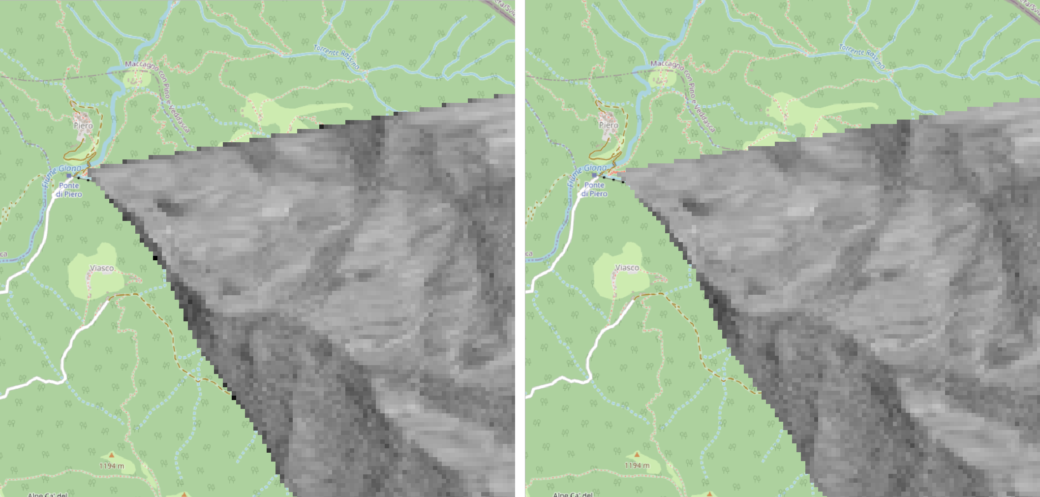
VV gamma0 RTC backscatter image visualizing the noisy border (left) and the cleaned result (right). The area covers approx. 2.3 x 2.3 km². Pixel spacing is 20 m. connectedness 4, 1 pixel.
- Parameters:
src (str) – a processed SAR image in BEAM-DIMAP format (.dim), a single .img file (ENVI format) or a directory with .img files. 0 is assumed as no data value.
only_boundary (bool) – only erode edges at the image boundary (or also at data gaps caused by e.g. masking during Terrain-Flattening)?
connectedness (int) – the number of pixel neighbors considered for the erosion. Either 4 or 8, translating to a
scipy.ndimage.generate_binary_structure()connectivity of 1 or 2, respectively.pixels (int) – the number of pixels to erode from the edges. Directly translates to iterations of
scipy.ndimage.iterate_structure().
- pyroSAR.snap.auxil.writer(xmlfile, outdir, basename_extensions=None, clean_edges=False, clean_edges_npixels=1)[source]
SNAP product writing utility
- Parameters:
xmlfile (str) – the name of the workflow XML file.
outdir (str) – the directory into which to write the final files.
basename_extensions (list of str or None) – names of additional parameters to append to the basename, e.g.
['orbitNumber_rel'].clean_edges (bool) – erode noisy image edges? See
pyroSAR.snap.auxil.erode_edges(). Does not apply to layover-shadow mask.clean_edges_npixels (int) – the number of pixels to erode.