DEM Preparation
SAR processing requires a high resolution Digital Elevation Model for ortho-rectification and normalization of terrain-specific imaging effects.
In SNAP, the DEM is usually auto-downloaded by the software itself and the user only specifies the DEM source to be
used, e.g. SRTM. pyroSAR’s convenience function pyroSAR.snap.util.geocode() can additionally pass SNAP’s option to use an
external DEM file via parameters externalDEMFile, externalDEMNoDataValue and externalDEMApplyEGM.
GAMMA does not provide ways to automatically download DEMs for processing and the user thus also needs to provide an external DEM file in GAMMA’s own format. However, several commands are available to prepare these DEMs including conversion from geoid heights to WGS84 ellipsoid heights.
pyroSAR offers several convenience functions to automatically prepare DEM mosaics from different sources to use them in either SNAP or GAMMA.
Download of DEM Tiles
The function pyroSAR.auxdata.dem_autoload() offers convenient download of tiles from different sources
overlapping with user-defined geometries. Optionally, a buffer in degrees can be defined.
Users can either mosaic the result in GDAL’s VRT format, return a file list with GDAL-readable paths
(e.g. pointing to a GeoTIFF inside a zip using the /vsizip/ directive), or just download products without any return.
When writing a VRT and crop=True (the default), the resulting mosaic is cropped to the extent of the (buffered) input geometry.
The crop argument does not have an effect when returning a file list.
Note
VRTs do not support mosaics crossing the antimeridian. Use a file list in this case.
from pyroSAR.auxdata import dem_autoload
from spatialist import bbox

extent = {'xmin': 11.5, 'xmax': 12, 'ymin': 50.5, 'ymax': 51}
vrt = 'mosaic.vrt'

with bbox(extent, crs=4326) as vec:
    dem_autoload(
        geometry=vec,
        demType='Copernicus 30m Global DEM',
        buffer=0.1,
        vrt=vrt,
    )
from pyroSAR.auxdata import dem_autoload
from spatialist import Vector

extent = {'xmin': 11.5, 'xmax': 12, 'ymin': 50.5, 'ymax': 51}


with bbox(extent, crs=4326) as vec:
    tiles = dem_autoload(
        geometry=vec,
        demType='Copernicus 30m Global DEM',
        buffer=0.1,
        return_fname=True
    )
For downloading tiles of some DEM types, an account needs to be created and the user credentials be passed to
function dem_autoload(). See the function’s documentation for further details.
The files are stored in SNAP’s location for auxiliary data, which per default is $HOME/.snap/auxdata/dem.
This path can be modified using pyroSAR.examine.ExamineSnap.auxdatapath.
DEM Mosaicing
In a next step we create a mosaic GeoTIFF using the function pyroSAR.auxdata.dem_create().
The spatial reference system, WGS84 UTM 32N in this case, is defined by its EPSG code but also several other options
are available (see function spatialist.auxil.crsConvert() for options).
Since for SAR processing we are interested in WGS84 ellipsoid heights (and not geoid heights as for most DEMs),
the function defaults to geoid_convert=True. The correct geoid model is inferred automatically from the input DEM type.
This function makes use of spatialist.auxil.gdalwarp().
Conversion of vertical reference systems, e.g. from geoid to ellipsoid, requires GDAL version >=2.2.
Since crop does not have an effect when returning a file list from
dem_autoload(),
geometry and buffer need also to be passed to
dem_create() to achieve the same result as with the VRT.
If omitting them, the result will be the same as if creating a VRT in
dem_autoload() with crop=False,
i.e. creating a mosaic covering the extent of all input DEM tiles.
from pyroSAR.auxdata import dem_create


outname = 'cop-dem.tif'


dem_create(
    src=vrt,
    dst=outname,
    t_srs=32632,
    tr=(20, 20)


)
from pyroSAR.auxdata import dem_create

extent = {'xmin': 11.5, 'xmax': 12, 'ymin': 50.5, 'ymax': 51}
outname = 'cop-dem.tif'

with bbox(extent, crs=4326) as vec:
    dem_create(
        geometry=vec,
        buffer=0.1,
        src=tiles,
        dst=outname,
        t_srs=32632,
        tr=(20, 20)
    )
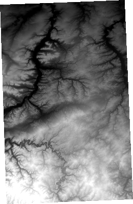
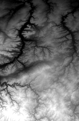
Next to the advantage of supporting the antimeridian case, the file list approach might also be preferred for the coverage of the output mosaic.
The mosaic created from a VRT covers exactly the EPSG:4326 extent of the input geometry plus buffer.
The mosaic created from the file list will cover the bounding box of the t_srs-projected extent of the input geometry plus buffer:
GAMMA Import
For convenience, pyroSAR’s gamma submodule contains a function pyroSAR.gamma.dem.dem_autocreate(), which is a
combination of functions dem_autoload() and dem_create() and further
executes GAMMA commands for format conversion.
It offers the same parameters as these two functions and a user can additionally decide whether geoid-ellipsoid
conversion is done in GDAL or in GAMMA via parameter geoid_mode. The output is a file in GAMMA format, which can
directly be used for processing by e.g. function pyroSAR.gamma.util.geocode().